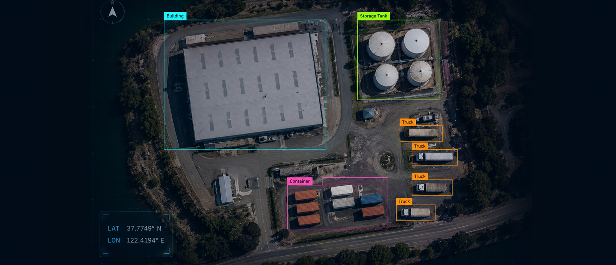
Most teams building AI models on aerial or satellite imagery discover the same thing at the same painful moment: after weeks of annotation, the model underperforms on real-world data. The labels look right. The annotators followed the guidelines. The Quality Assurance (QA) numbers came back clean. And yet the model keeps making the same mistakes.
The instinct is usually to blame the annotators, tool calibration, or dataset size. But in many aerial annotation projects, the actual cause lies further upstream — in the data annotation guidelines themselves.
Generic image annotation guidelines, especially those developed for close-range RGB imagery, dashcam footage, CCTV feeds, and street-level object detection, encode a set of visual assumptions that hold at eye level. At altitude, those assumptions break. Not in every image, not in a way that is easy to catch on a standard accuracy review, but consistently enough that the model learns the wrong thing and fails precisely when and where it matters most.
The Ground-Level Assumptions That Fail at Altitude
Standard data annotation guidelines are based on implicit assumptions about how objects appear in images. Each becomes unreliable the moment a camera leaves the ground.
1. Scale Stability
Street-level cameras operate within predictable, narrow distance bands. A vehicle at 10 meters may look smaller than one at 2 meters, but it still retains a massive, high-density pixel footprint and a distinct, multi-angle silhouette. Annotation guidelines for this environment specify minimum bounding box sizes, margin rules, and label criteria based on that predictable scale.
In aerial imagery, the same vehicle might occupy 400 pixels at 50 meters altitude and fewer than 10 pixels at 300 meters. The DOTA v2 dataset — one of the largest aerial object detection benchmarks, with over 1.79 million annotated instances across 11,268 aerial images — documents this directly: the massive scale variation across different instances caused by the bird's-eye view is a primary reason standard detection approaches fail on aerial data.
Guidelines that specify label criteria around a standard pixel footprint will, at lower resolutions, either miss objects entirely or generate bounding boxes so imprecise they introduce more noise than signal. Yet most guidelines lack a resolution floor, because scale ambiguity simply does not exist at street level. A guideline that says "annotate every visible vehicle" will produce systematically different datasets depending on flight altitude — even with identical annotators and identical terrain — because visibility itself is altitude-dependent.
2. Boundary Visibility
Ground-level objects generally have visible, continuous edges. A pedestrian in a dashcam frame has a clear silhouette against a road or pavement. Annotation guidelines written around this reality typically instruct annotators to trace object boundaries, draw tight bounding boxes, or perform pixel-level segmentation along visible contours.
Aerial occlusion is structurally different. At ground level, objects hide behind other objects in the foreground. From above, objects do not disappear behind foreground elements — they compress into one another under top-down projection. When cattle stand close together in a feedyard, when vehicles park bumper-to-bumper, when fallen trees overlap in a river channel, the aerial perspective merges them into a single visual mass.
The VisDrone benchmark, which compiled more than 2.5 million annotated bounding boxes from drone footage, documents this specifically: in dense scenes, the overlap between adjacent bounding boxes becomes so large that standard detection methods cannot differentiate instances. The annotation guidelines had not failed — they were followed correctly. The problem was the guideline assumed an object had a distinct boundary, and at altitude, many objects simply do not.
3. Object Completeness
Ground-level annotation generally assumes objects are either fully visible or not visible at all. There is partial occlusion, but the core assumption is the annotated object has a recognizable form and is reasonably complete within the frame.
From altitude, object completeness is determined by image resolution, sensor tilt, and flight geometry — none of which the annotator controls. A cow photographed from directly above at 100 meters altitude appears as a compressed oval with no visible features that identify it as a cow. The same animal at a slight camera tilt from 60 meters may show enough body geometry to be unambiguously identified. A guideline that says "label cattle" without specifying which visual cues constitute sufficient evidence will produce inconsistent results among annotators working on the same dataset.
A 2025 PLOS ONE study on observer reliability in aerial wildlife imagery found this directly. Even among expert annotators working on the same images, agreement on fine-grained species classification dropped from 99% for broad morphological categories to 75% for narrower classifications — driven primarily by spatial resolution and texture attributes rather than annotator competence.
4. Sensor Neutrality
Ground-level guidelines are almost entirely agnostic to the sensor that captured the image. At ground level, sensor variation rarely changes an object's appearance enough to matter.
In aerial and satellite imagery, the sensor is part of the problem. At high altitude, a cloud passing between the sun and the ground doesn't just make the image darker; it changes the spectral quality of the light hitting the camera sensor. If the downwelling light sensor fails to calibrate for that split-second shift, a blue SUV in the shade suddenly yields pixel-level radiometric values different from those of a blue SUV in direct sunlight. To the computer vision model, they look like two entirely different objects.
Camera tilt angle, flight altitude, vibration-induced blur, and lens distortion all influence how an object's boundaries and spectral signature appear in the final image. For satellite annotation, this means the same physical object can appear to belong to a different class depending on when the image was captured, at what altitude, and under what lighting conditions.
5. Clear-Scene Continuity
Ground-level annotation often assumes the scene is visually stable enough for objects to remain distinguishable across frames or images. Aerial imagery breaks that assumption. Cloud shadows, haze, snow cover, water glare, smoke, seasonal vegetation, and overexposure can change class boundaries without changing the underlying object.
Weather artifacts do not always look like noise. A shadow may look like water. Snow cover may hide road edges. Haze may erase small vehicles. Sun glint may make water, ice, or metal surfaces appear as a different class. Without weather-specific rules, annotators begin making case-by-case judgments, resulting in inconsistent training signals.
Why Standard QA Fails on Aerial Data
The problems above are annotation-layer failures. But there is a compounding problem: the standard QA protocols used to check annotation work are usually designed around the same ground-level assumptions, so they often fail to detect issues specific to drone, satellite, or aerial captures.
Inter-Annotator Agreement (IAA) Can Mislead
Inter-Annotator Agreement — the standard measure of labeling consistency — assumes that if two annotators independently label the same image similarly, the labels are correct. In aerial annotation, this assumption is unreliable. Two annotators can agree on an incorrect label because both are applying the same flawed guideline to an ambiguous aerial image.
Consider a rule: "If a passenger vehicle has a separate rear cargo bed, label it a Truck; otherwise, Car/SUV." A drone at 300m on a partly cloudy day casts a shadow over a 12-pixel SUV. Two annotators both misinterpret the dark gradient as an open cargo bed and label "Truck." IAA now registers a perfect 100% agreement score on a corrupted data point. High IAA on aerial data can mask systematic labeling errors that only surface when the model fails on production data.
Sample-Based Review Misses Edge Cases
Standard accuracy review samples completed annotations and checks them against a known reference. In aerial projects, this works for clearly visible instances but fails on the edge cases that drive model performance: sub-threshold objects near the minimum pixel floor, partial-overlap occlusions in dense scenes, and seasonally variable spectral signatures. These cases appear infrequently enough in random sampling that they do not trigger accuracy thresholds — until the model hits them at scale in production.
QA Protocols Built for Aerial Workflows
The projects that avoid re-annotation cycles and model failure patterns share a set of QA practices that are not part of standard ground-level workflows.
Resolution-Tiered Annotation Rules
Rather than a single guideline with a single minimum-size threshold, effective aerial specs define different labeling criteria for different altitude ranges and Ground Sampling Distance values. Objects below the usable signal floor are explicitly excluded from labeling rather than left to the annotator's judgment. This eliminates inconsistency between annotators who label small objects and those who do not.
Capture-Condition Cohort Review
Group images by capture condition — altitude range, season, weather state, sensor configuration — and review within those groups. If annotators in the spring-thaw cohort consistently disagree on Ice-Slush boundaries while the winter cohort shows high agreement, the problem lies in the guideline's handling of a specific capture condition, not in annotator quality.
Automated Annotation Drift Detection
In large-scale aerial projects with extended timelines, annotators' interpretations shift subtly over time even when guidelines remain unchanged — a phenomenon known as annotation drift. Custom drift detection scripts that analyze clusters of related images (same river bend, same season, different time points) can identify shifts in labeling behavior across time and between annotators, flagging anomalies for Subject Matter Expert review before they propagate.
Object-Specific Edge Case Libraries
Standard QA workflows document errors after they occur. Aerial annotation projects require edge-case libraries built before annotation begins — visual reference guides with annotated examples of merged objects at altitude, objects at the minimum pixel threshold, sensor-distorted boundaries, and objects obscured by cloud shadow.
Five Questions Every Aerial Annotation Schema Must Answer
Before aerial annotation begins on any drone, UAV, or satellite captured images, the schema needs to address five questions that ground-level guidelines do not ask:
- What is the altitude range and GSD range across this dataset, and what is the minimum pixel threshold for each object class at each resolution tier?
- How does occlusion manifest for the specific object types in this dataset at the relevant altitude, and what does "complete enough to label" mean in that context?
- Which capture conditions (season, weather, sensor configuration, flight geometry) create visual ambiguity for the classes being annotated, and how does the guideline handle each one?
- What is the calibration protocol for annotators across different capture condition cohorts, and how will inter-annotator agreement be measured within those cohorts rather than in aggregate?
- How will annotation drift be monitored for a dataset of this volume and duration?
Teams that invest in preparation at the guideline stage avoid the costly realization during model validation that the training data reflects annotator judgments about an imprecise specification rather than the ground truth about what the model needs to learn.
Get the Guidelines Right Before Annotation Begins
Getting the guidelines right before annotation begins is the decision that determines everything else. If your next aerial, drone, or satellite project is still in the planning stage, that is the right moment to start: with schema design and ontology development as the first step — before a single label is placed.